We are anticipating the publication of Knitting Wester Ross today, and the team is ready (and waiting) in the KDD warehouse to begin the process of shipping the book out to club members, before putting it on general sale. This interim – between the completion of a book and its publication – is often a time for reflection for me, and I’ve been thinking in recent days about how much I learn from the process of working on one of our projects. Quite apart from the design work (which always has new things to teach me), I often find myself discovering something completely new (to me); something I had no idea I was interested in in advance, a rich area of enquiry, which opens up further, interesting questions. The work Tom and I did on Rubha nan Sasan was one such area of enquiry.

I had done some research previously about British archaeology and World War II in a piece I produced for Argyll’s Secret Coast . While this earlier essay explored attempts, in the early 1940s, to produce a documentary record of Scotland’s pre-historic landscape (under the assumption that ancient monuments were likely to be destroyed by bombs), the Rubha nan Sasan work was about the concrete legacies of war at a distance of 80 years. I was essentially trying to think about how the hastily-erected structures of World War II had become the archaeology of the future – our archaeology.

While I was formulating some ideas about the landscape, archaeology and heritage of Rubha nan Sasan, I was also reading Jonathan Freedland’s excellent The Traitor’s Circle – a book about a group of elite Germans, who formed a small determined core of resistance in Berlin, and who (among other brave acts) helped many Jews to escape. Their wartime story was gripping and moving, but I found the book’s most powerful chapters to be its final ones, in which Freedland reveals the slow unravelling of those in the group who managed to survive, over decades of accumulated trauma. And at the same time as all of this, of course, I was also looking every day at the grim spectacle of destruction in the Middle East, and thinking about the future legacies of our wars, our future archaeology, future trauma.

All of this, then formed the backdrop of what I eventually wrote for Rubha nan Sasan, from which I really learned an awful lot. I thought I’d reproduce that essay here today (for those of you who were not club members) and you can explore more of the amazing infrared photographs Tom shot for this project, beautifully printed in Ootlier 6.

Rubha nan Sasan
In 1942, Angus Graham and Gordon Childe were commissioned to make an emergency survey of Scotland’s monuments, preserving archeological records for posterity. But unlike in England, where the emphasis of such projects was the change inevitable in the event of widely-anticipated enemy invasion, Childe and Graham were also urgently concerned by the domestic transformation of Scotland’s landscape under conditions of total war.

A fifth of Scotland’s land mass had been appropriated for military purposes, Neolithic structures had already been damaged by artillery on a firing range, and the monumental remains of Scotland’s ancient landscape increasingly sat cheek by jowl with rapidly-erected buildings which would form its future archaeology. Over a few short months in 1941, thousands of tonnes of reinforced concrete and equivalent hours of human labour had been poured into the accelerated construction of infrastructure all over Highland Scotland and the landscape which Childe and Graham were documenting already looked radically different to its appearance of a few years earlier.

Huge airfields, access routes, training areas, accommodation blocks, searchlight installations, anti-aircraft batteries, pillbox guard-posts, gun emplacements and complex coastal defences had suddenly sprung up as large parts of Scotland’s north and west were cut off from civilian movement and observation. As the preferred locations for armed-forces training and weapons development (including biological warfare tests at Gruinard Island), these requisitioned, increasingly concrete-covered areas of Scotland became highly secretive, heavily defended, completely militarised zones.

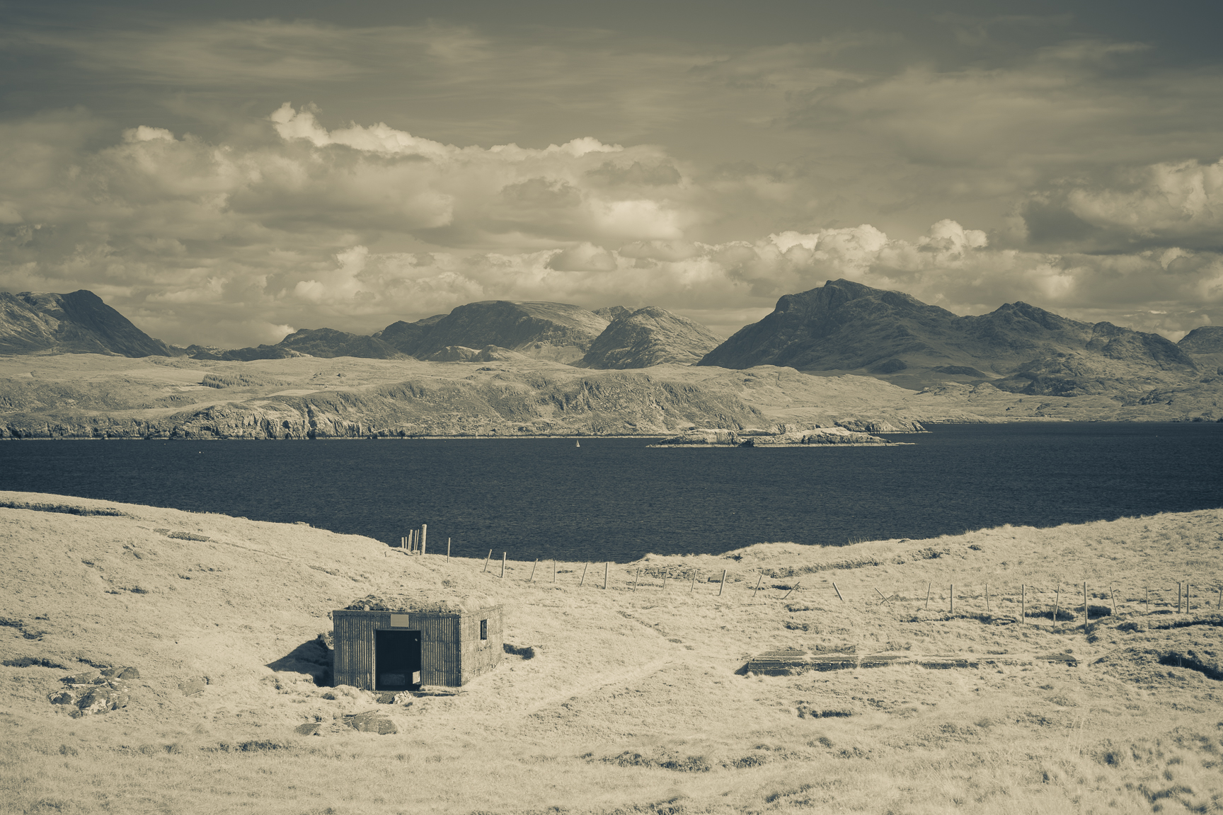
One of these secretive militarised areas was Loch Ewe, which had been designated “Port A” by the Admiralty after the torpedoing of the Royal Oak at Scapa Flow. The sheltered sea loch was wide and deep, its mouth narrow and overlooked: it was the ideal place to hide the vessels engaged in the desperate and dangerous work of the Arctic Convoys that were needed to supply vital resources to wartime Russia. Over a thousand servicemen and women were stationed around Loch Ewe, and while its clear waters grew dark and black with ships, the surrounding landscape bristled with the new infrastructure that was necessary to protect them. Mellon Charles housed a boom defence base to service the anti-submarine nets encircling the loch’s mouth while at Tournaig, a command post and barrage balloon station dominated the hillside. A string of distinctive anti-aircraft gun emplacements covered the length of the loch side from Poolewe to Naast, but it was Rubha nan Sasan—Loch Ewe’s headland of “difficulty”—that was perhaps most significantly altered by the area’s wartime redevelopment.

Here, in 1941, an emergency coastal battery was rapidly constructed to protect the loch’s anchorage and provide cover for the security ship which verified every vessel entering “Port A.” In addition to the large observation post from which this continual surveillance was conducted, there were two gun houses, two searchlights, a series of smaller buildings to house generators and engines, storage facilities, and several anti-aircraft gun emplacements.

Accommodation blocks were also built, together with a network of concrete tracks to enable the movement of artillery, munitions and personnel over the cliffside’s uneven ground.

Before the war, Rubha nan Sasan had been a place shaped only by the long, slow work of weather, water and small-scale crofting. Smoothed and worn away by millennia, the rough, irregular contours of this coastal landscape now sat in curiously stark contrast to the straight lines and sharp angles of the headland’s brand-new modern(ist) military architecture.

Between 1941 and 1945 not a single shot was ever fired in anger from the orthogonal structures of the battery at Rubha nan Sasan.

Those who were stationed in its concrete fortress endured difficult conditions—the long cold nights and howling gales of an exposed Highland cliffside—but they were also impressed by the extraordinary grandeur and beauty of the surrounding landscape, praised local hospitality, and wrote warmly of the cinema, dances, and jellyjar pints they enjoyed in nearby Aultbea.

Other members of Loch Ewe’s transitional wartime population were less fortunate. Around 3000 allied personnel were killed in the Arctic Convoys, including the 153 merchant seamen who died after being abandoned by their naval escorts in PQ17.

Rubha nan Sasan was not unusual. Tens of thousands of comparable orthogonal military structures—from guard-posts to coastal batteries—were constructed all over wartime Britain. Yet today, surprisingly little evidence of the frenetic construction activity of 1941 remains (for example, it’s estimated that 94% of anti-aircraft gun emplacements and more than 80% of pillboxes have been removed).

After 1945, successive British governments spent approximately £150 million (adjusted for inflation, in today’s terms) dismantling what they could of this concrete infrastructure, prioritising highly populated areas and “heritage” landscapes where objects and buildings with a military appearance were deemed to be “intrusive”.

Later, in the 1960s and 70s, high-profile campaigns by the National Trust, local residents’ associations and county councils – often accompanied by petty and alarmist rhetoric about invading forces of squatters, travellers, naturists and gay men – further expedited the removal of hundreds of concrete “eyesores” around the English home counties and the southern English coast.

In less populated (or less nimbyist) areas of England and Scotland, some of Britain’s remaining wartime buildings were repurposed or redeveloped by NATO and the ROC (Royal Observer Corps) as part of the work of monitoring nuclear threat at the height of the Cold War. But as the “protect and survive” era in its turn passed into memory, so the concrete bunkers and lookout posts fell once again into disuse, and a new debate began about the built legacy of total war in Britain.

Might 1940s concrete structures be regarded as historic monuments? As important examples of vernacular architecture? As archaeology? As heritage?

The military installations of 1941 are all of these things at once, of course, and perhaps the distance of 80 years enables all of us (including the National Trust, who now manage sites like Orford Ness) to regard these Second World War remains as what they are: integral—albeit contested and debatable—parts of Britain’s twentieth-century landscape and historical narrative.

Around Scotland, many of these structures have now been repurposed as excellent destinations or places in which to stay: at Kintyre’s Davaar Island you can spend your holiday in a spectacularly located wartime lookout station, while at Connel, a little over half a million pounds will buy you the group headquarters for no. 27 Royal Observer Corps, tastefully converted into a residential dwelling. Near St Andrews, you can now hire anunderground nuclear command centre for your corporate event or wedding, while Gairloch’s award-winning museum has transformed an unprepossessing Cold War bunker into an impressive, contemporary space for the celebration of local history and heritage.

Things look very different at a distance of 80 years, and yet they can also look much the same, as they do, perhaps, at Rubha nan Sasan, where surprisingly little seems to have changed since the last troops abandoned their posts in 1945.

Receiving scheduled monument designation as part of the Defence Areas Project of the early 1990s, its remaining concrete structures have been described as “arguably the most outstanding surviving emergency coast battery in Scotland and possibly the UK. . . . The condition and extent of the battery, with so many surviving elements,” the designation concludes, “make it a rare example which enables less well-preserved or documented sites to be more easily identified and interpreted.”

In 1975, Paul Virilio wrote of the curious cultural invisibility of the gigantic concrete structures of Hitler’s Atlantic Wall, whose un-seeing bespoke a particular kind of failure to engage with the Second World War and its legacies of violence.

Fifty years later, some of us still don’t really want to see similar concrete legacies in the Scottish Highlands, perhaps because such structures trouble our fantasies of an appropriately national picturesque.

A recent guidebook suggests visiting Rubha nan Sasan simply to look beyond it “for the view”, while a popular TV historian’s 2024 Highlands and Islands travelogue finds it “impossible to imagine the violent reality of war,” from the perspective of Loch Ewe’s “remote” and windswept headland.

But why might we be so fascinated by more distant histories of violence (and their accompanying picturesque ruins) but want to look past these modern(ist) military structures to the lofty, empty hills beyond? Why should this coastal battery be regarded so very differently to Scotland’s most-photographed fortification, Eilean Donan . . . .

. . . whose modern (re)construction was in fact only completed in 1932, a mere 9 years before the concrete fortress of Rubha nan Sasan appeared?

From the massacre at Dunaverty Rock to the brutal murders of Castle Sinclair Girnigoe, Scotland’s coastline is, in fact, one, long monumental trail of violence but perhaps some kinds of coastal battery are just more instagrammable than others.

Supported by the work of the Arctic Convoy Museum and the Russian Convoy Club (whose small, dignified memorial stands on a rocky outcrop above Rubha nan Sasan), the once secretive military landscape of Loch Ewe has now been opened up through interpretive contexts which make its important 1940s story both visible and legible.

In Aultbea, Gairloch and Poolewe, you’ll find beautiful mosaics designed by local children commemorating the wartime experiences of their local communities, while a thoughtful visitor trail, accompanied by interpretation panels and well-designed silhouette artworks enable the viewer to envisage the utterly radical transformations enacted by “Port A” upon the peaceful spaces of Loch Ewe.

At Mellon Charles, one such silhouette reveals the heavy human labour involved in shifting boom weights, while beyond the artwork, the material remains of the concrete weights themselves can be seen on the foreshore, quietly tilting away into the coastal landscape.

The artworks, the panels and the trail prompt in the visitor a different kind of noticing, demystifying Loch Ewe’s cryptic military remains, and enabling useful reflection upon the human and environmental legacies of conflict.

The thing that I perhaps find most intriguing about Rubha nan Sasan is the way that it forces us to see, and to question our ways of seeing. Tom’s powerful images—whose detail, clarity and echoing geometric forms really capture the insistent presence of this special place—ask you to do just that.

Do you find Rubha nan Sasan unappealing or repellent? If you feel distaste or repulsion, is that prompted by the brutal structures themselves or by a knowledge of their military function and potential for violent action?

How might your personal memories of Fascism, Communism or the nuclear threats of the Cold War colour your perception of this place? How does the wider Highland Scottish landscape which you glimpse in these photographs speak to you? What does it say?
Do you find the contrast between the coastal battery and its spectacular location disturbing or off-putting? Or do you, like me, find the disjunction between these unsettling structures and their gorgeous environs strangely compelling, because it is precisely there that a gap might open up for understanding?

Please support Tom’s work by purchasing a copy of Rubha nan Sasan for yourself or someone who might be interested
Further Reading
Steve Chadwick, Loch Ewe During World War II (2014)
William Foot, Beaches, Fields, Streets and Hills: The Anti-Invasion Landscapes of England, 1940 (2006)
George F Geddes, “The Royal Commission on the Ancient and Historical Monuments of Scotland, Angus Graham and Gordon Childe (1935-46)”, Proc Soc Antiq Scot 146 (2106) 275-309
Julia Hell and Andreas Schönle, eds Ruins of Modernity (2010)
Inge Hermann, “‘A Nice Day Out?’ Exploring Heritage and Tourism Discourses at Cold War Bunker Sites in Britain” in Luke Bennet ed, In the Ruins of the Cold War Bunker: Affect, Materiality and Meaning Making (2018)
Paul Readman, “Landscapes of Military Modernity: From ‘Eyesores’ to National Heritage?” in Ben Anderson, Matthew Kelly, Katrina Navickas and Linda Ross eds, New Lives, New Landscapes Revisited (2023)
Paul Virilio, Bunker Archaeology (1975)
Links
Leave a Reply